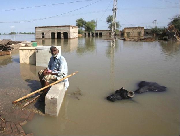
ISLAMABAD, Aug 12 (APP): River Indus is flowing in exceptionally high flood with falling trend in Guddu – Sukkur reach with water outflow of 996,000 and 1,090,000 cusecs and in very high flood with rising trend in Chashma- Taunsa reach with water discharge of 796,000 and 762,000 cusecs respectively. According to daily report issued by Federal Flood Commission here, the river is in high flood with falling trend at Kalabagh and in medium Flood with falling trend at Tarbela.
River Kabul is in very high flood with falling trend at Nowshera with water outflow of 208,000 cusecs and in medium flood with falling trend at Warsak with water discharge of 79,000 cusecs. River Chenab is also experiencing medium flood in Trimmu-Panjnad reach with water discharge of 293,000 cusecs while River Jhelum in Low flood at Mangla-Rasul reach with outflow of 91,000 cusecs. The flood peak of exceptionally high flood level is likely to pass through Kotri during the next 24-48 hours which can cause inundation and riverine flooding of low lying areas of Districts Hyderabad, Thatta and adjoining areas along the river.
According to the latest hydrological conditions as reported by Flood Forecasting Division Lahore, River Indus at Kalabagh is likely to attain very high flood level ranging between 690,000 to 780,000 cusecs during the next 24 hours.
River Indus at Chashma is also likely to attain Very High to Exceptionally High Flood Level ranging between 780,000 to 820,000 cusecs during the same period. Under this scenario, low lying and riverine areas of Districts Mianwali, D. I. Khan, Bhakkar and Layyah may come under inundation. River Indus at Guddu is likely to sustain exceptionally high flood level upto 1,000,000 cusecs during the next 3-4 days which can cause inundation and riverine flooding of low lying areas of Districts Khairpur, Jacobabad, Ghotki and Sukkur.
River Indus at Sukkur is also likely to continue exceptionally high flood level upto 1,000,000 cusecs during the next 3-4 days.
Tarbela and Mangla Dams are at elevations of 1539.22 feet and 1206.00 feet, respectively, which are 10.78 feet and 4.00 feet below their respective Maximum Conservation Levels of 1550.00 feet and 1210.00 feet. The combined live storage position of Tarbela, Mangla & Chashma is 10.974 MAF as compared to last year?s 11.190